KASHMIR
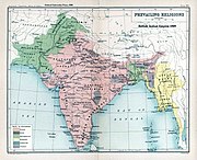
Kashmir (Balti: کشمیر; Dogri:, Poonchi/Chibhali: کشمیر; Kashmiri: कॅशीर, کٔشِیر; Ladakhi: ཀཤམིར; Shina: کشمیر; Uyghur: كھسىمڭر) is the northwestern region of the Indian subcontinent. Until the mid-19th century, the term "Kashmir" referred only to the valley lying between the Great Himalayas and the Pir Panjal range. since then, it has been used for a larger area that today includes the Indian administered state of Jammu and Kashmir consisting of the Kashmir valley, Jammu and Ladakh; the Pakistani-administered provinces of the Northern Areas and Azad Kashmir, and the Chinese-administered, mostly uninhabited, regions of Aksai Chin and Trans-Karakoram Tract. In the first half of the first millennium, Kashmir became an important center of Hinduism and later of Buddhism; later still, in the ninth century, Kashmir Shaivism arose in the region. The heritage of Kashmir during this period is well documented in Rajatarangini by Kalhana. In 1349, Shah Mir became the first Muslim ruler of Kashmir and inaugurated the line Salatin-i-Kashmir. For the next five centuries Kashmir had Muslim monarchs, including the Mughals, who ruled until 1751, and thereafter, the Afghan Durranis, who ruled until 1820. That year, the Sikhs under the Jat-Sikh King Ranjit Singh, annexed Kashmir. In 1846, upon the purchase of the region from the British under the Treaty of Amritsar, the Dogras under Gulab Singh became the new rulers. Dogra Rule, under the paramountcy (or tutelage) of the British Crown, lasted until 1947, when the former princely state became a disputed territory, now administered by three countries: India, Pakistan, and the People's Republic of China. The Nilamata Purana describes the Valley's origin from the waters, Ka means "water" and Shimir means "to desiccate". Hence, Kaashmir stands for "a land desiccated from water", or vale. There is also a theory which takes Kaashmir to be a contraction of Kashyap-mira or Kashyapmir or Kashyapmeru, the "sea or mountain of Kashyapa", the sage who is credited with having drained the waters of the primordial lakeSatisar, that Kaashmir was before it was reclaimed. The Nilamata Purana gives the name Kaashmira to the Valley considering it to be an embodiment of Uma and it is the Kaashmir that the world knows today. The Kaashmiris, however, call it Kashir, which has been derived phonetically from Kaashmir, as pointed out by Aurel Stein in his introduction to the Rajatarangini. In the Rajatarangini, a history of Kashmir written by Kalhana in the 12th century, it is stated that the valley of Kaashmir was formerly a lake. This was drained by the great rishi or sage, Kashyapa, son of Marichi, son of Brahma, by cutting the gap in the hills at Baramulla (Varaha-mula). Cashmere is a variant spelling of Kaashmir. The Mauryan emperor Ashoka is often credited with having founded the city of Srinagar. Kashmir was once a Buddhist seat of learning, perhaps with the Sarvāstivādan school dominating. East and Central Asian Buddhist monks are recorded as having visited the kingdom. In the late 4th century AD, the famous Kuchanese monk Kumārajīva, born to an Indian noble family, studied Dīrghāgama and Madhyāgama in Kashmir under Bandhudatta. He later became a prolific translator who helped take Buddhism to China. His mother Jīva is thought to have retired to Kashmir. Vimalākṣa, a Sarvāstivādan Buddhist monk, travelled from Kashmir to Kucha and there instructed Kumārajīva in the Vinayapiṭaka. The Muslims and Hindus of Kashmir lived in relative harmony, since the Sufi-Islamic way of life that a few ordinary Muslims followed in Kashmir complemented the Rishi tradition of Kashmiri Pandits.This led to a syncretic culture where Hindus and Muslims revered the same local saints and prayed at the same shrines. Famous sufi saint Bulbul Shah was able to convert Rinchan Shah who was then prince of Kashgar Ladakh to an Islamic lifestyle, thus founding the Sufiana composite culture. Under this rule, Muslim, Hindu and Buddhist Kashmiris generally co-existed peacefully. Over time, however, the Sufiana governance gave way to outright Muslim monarchs. Some Kashmiri rulers, such as Sultan Zain-ul-Abidin, were tolerant of all religions in a manner comparable to Akbar. However, several Muslim rulers of Kashmir were intolerant of other religions. Sultãn Sikandar Butshikan of Kashmir (AD 1389-1413) is often considered the worst of these. Historians have recorded many of his atrocities. The Tarikh-i-Firishta records that Sikandar persecuted the Hindus and issued orders proscribing the residence of any other than Muslims in Kashmir. He also ordered the breaking of all "golden and silver images". The Tarikh-i-Firishta further states: "Many of the Brahmins, rather than abandon their religion or their country, poisoned themselves; some emigrated from their native homes, while a few escaped. After the emigration of the Brahmins, Sikandar ordered all the temples in Kashmir to be thrown down. Having broken all the images in Kashmir, (Sikandar) acquired the title of ‘Destroyer of Idols’." The metrical chronicle of the kings of Kashmir, called Rajatarangini, has been pronounced by Professor H.H.Wilson to be the only Sanskrit composition yet discovered to which the appellation "history" can with any propriety be applied. It first became known to the Muslims when, on Akbar's invasion of Kashmir in 1588, a copy was presented to the emperor. A translation into Persian was made at his order. A summary of its contents, taken from this Persian translation, is given by Abul Fazl in the Ain-i-Akbari. The Rajatarangini was written by Kalhana about the middle of the 12th century. His work, in six books, makes use of earlier writings that are now lost. The Rajatarangini is the first of a series of four histories that record the annals of Kashmir. Commencing with a rendition of traditional history of very early times, the Rajatarangini comes down to the reign of Sangrama Deva, (c.1006 AD). The second work, by Jonaraja, continues the history from where Kalhana left off, and, entering the Muslim period, gives an account of the reigns down to that of Zain-ul-ab-ad-din, 1412. P. Srivara carried on the record to the accession of Fah Shah in 1486. The fourth work, called Rajavalipataka, by Prajnia Bhatta, completes the history to the time of the incorporation of Kashmir in the dominions of the Mogul emperor Akbar, 1588. By the early 19th century, the Kashmir valley had passed from the control of the Durrani Empire of Afghanistan, and four centuries of Muslim rule under the Mughals and the Afghans, to the conquering Sikharmies. Earlier, in 1780, after the death of Ranjit Deo, the Raja of Jammu, the kingdom of Jammu (to the south of the Kashmir valley) was captured by the Sikhs under Ranjit Singh of Lahore and afterwards, until 1846, became a tributary to the Sikh power. Ranjit Deo's grandnephew, Gulab Singh, subsequently sought service at the court of Ranjit Singh, distinguished himself in later campaigns, especially the annexation of the Kashmir valley by the Sikhs army in 1819, and, for his services, was appointed governor of Jammu in 1820. With the help of his officer, Zorawar Singh, Gulab Singh soon captured Ladakh and Baltistan, regions to the east and north-east of Jammu. In 1845, the First Anglo-Sikh War broke out, and Gulab Singh "contrived to hold himself aloof till the battle of Sobraon (1846), when he appeared as a useful mediator and the trusted advisor of Sir Henry Lawrence. Two treaties were concluded. By the first the State of Lahore (i.e. West Punjab) handed over to the British, as equivalent for (rupees) one crore of indemnity, the hill countries between Beas and Indus; by the second the British made over to Gulab Singh for (Rupees) 75 lakhs all the hilly or mountainous country situated to the east of Indus and west of Ravi" (i.e. the Vale of Kashmir). Soon after Gulab Singh's death in 1857, his son, Ranbir Singh, added the emirates of Hunza, Gilgit and Nagar to the kingdom. The Princely State of Kashmir and Jammu (as it was then called) was constituted between 1820 and 1858 and was "somewhat artificial in composition and it did not develop a fully coherent identity, partly as a result of its disparate origins and partly as a result of the autocratic rule which it experienced on the fringes of Empire." It combined disparate regions, religions, and ethnicities: to the east, Ladakh was ethnically and culturally Tibetan and its inhabitants practised Buddhism; to the south, Jammu had a mixed population of Hindus, Muslims and Sikhs; in the heavily populated central Kashmir valley, the population was overwhelmingly Sunni Muslim, however, there was also a small but influential Hindu minority, the Kashmiri brahmins or pandits; to the northeast, sparsely populated Baltistan had a population ethnically related to Ladakh, but which practised Shi'aIslam; to the north, also sparsely populated, Gilgit Agency, was an area of diverse, mostly Shi'a groups; and, to the west, Punch was Muslim, but of different ethnicity than the Kashmir valley. After the Indian Rebellion of 1857, in which Kashmir sided with the British, and the subsequent assumption of direct rule by Great Britain, the princely state of Kashmir came under the suzerainty of the British Crown. Ranbir Singh's grandson Hari Singh, who had ascended the throne of Kashmir in 1925, was the reigning monarch in 1947 at the conclusion of British rule of the subcontinent and the subsequent partition of the British Indian Empire into the newly independent Union of India and the Dominion of Pakistan. As parties to the partition process, both countries had agreed that the rulers of princely states would be given the right to opt for either Pakistan or India or—in special cases—to remain independent. In 1947, Kashmir's population "was 77% Muslim and it shared a boundary with Pakistan. Hence, it was anticipated that the Maharaja would accede to Pakistan, when the British paramountcy ended on 14-15 August. When he hesitated to do this, the adjacent Muslims in newly created Pakistan along with many Pashtun began to enter his territory. The Maharaja, appealed to Mountbatten for assistance, and the Governor-General agreed and demanded that the ruler first accede to India before assistance." Once the Maharaja signed the Instrument of Accession, "Indian soldiers entered Kashmir and drove the Pakistani-sponsored irregulars from all but a small section of the state. The United Nations was then invited to mediate the quarrel. The UN mission insisted that the opinion of Kashmiris must be ascertained, while India insisted that no referendum could occur until all of the state had been cleared of irregulars." In the last days of 1948, a ceasefire was agreed under UN auspices; however, since the plebiscite demanded by the UN was never conducted, relations between India and Pakistan soured, and eventually led to two more wars over Kashmir in 1965 and 1999. India has control of about half the area of the former princely state of Jammu and Kashmir; Pakistan controls a third of the region, the Northern Areas and Azad Kashmir. According to Encyclopaedia Britannica, "Although there was a clear Muslim majority in Kashmir before the 1947 partition and its economic, cultural, and geographic contiguity with the Muslim-majority area of the Punjab (in Pakistan) could be convincingly demonstrated, the political developments during and after the partition resulted in a division of the region. Pakistan was left with territory that, although basically Muslim in character, was thinly populated, relatively inaccessible, and economically underdeveloped. The largest Muslim group, situated in the Valley of Kashmir and estimated to number more than half the population of the entire region, lay in Indian-administered territory, with its former outlets via the Jhelum valley route blocked." The UN Security Council on 20 January 1948 passed Resolution 39, establishing a special commission to investigate the conflict. Subsequent to the commission's recommendation, the Security Council ordered in its Resolution 47, passed on 21 April 1948, that the invading Pakistani army retreat from Jammu & Kashmir and that the accession of Kashmir to either India or Pakistan be determined in accordance with a plebiscite to be supervised by the UN. The Government of India holds that the Maharaja signed a document of accession to India on October 26, 1947. Pakistan has disputed whether the Maharaja actually signed the accession treaty before Indian troops entered Kashmir, and claims that the he signed it under duress. Furthermore, Pakistan claims the Indian government has never produced an original copy of this accession treaty and thus its validity and legality is disputed. However, India has produced the instrument of accession with an original copy image on its website. Maharaja Hari Singh later died in Mumbai in 1962. Alan Campbell-Johnson, the press attaché to the Viceroy of India states that "The legality of the accession is beyond doubt." Pakistan was of the view that the Maharaja of Kashmir had no right to call in the Indian Army, because he was merely a British appointee and not a hereditary ruler. Hence Pakistan decided to take some action but British appointed Army Chief of Pakistan Douglas Gracey did not send troops to the Kashmir front and refused to obey the order to do so given by Mohammad Ali Jinnah,Governor-General of Pakistan. His argument was that the Indian forces occupying Kashmir represented the British Crown and so did he hence he could not engage in a military encounter with Indian forces. Pakistan finally did manage to send troops to Kashmir but by then the Indian forces had taken control of two-thirds the territory of Kashmir. The eastern region of the erstwhile princely state of Kashmir has also been beset with a boundary dispute. In the late 19th- and early 20th centuries, although some boundary agreements were signed between Great Britain, Afghanistan and Russia over the northern borders of Kashmir, China never accepted these agreements, and the official Chinese position did not change with the communist takeover in 1949. By the mid-1950s the Chinese army had entered the north-east portion of Ladakh. "By 1956–57 they had completed a military road through the Aksai Chin area to provide better communication between Xinjiang and western Tibet. India's belated discovery of this road led to border clashes between the two countries that culminated in the Sino-Indian war of October 1962." China has occupied Aksai Chin since the early 1950s and, in addition, an adjoining region almost 8% of the territory, the Trans-Karakoram Tract was ceded by Pakistan to China in 1963. Meanwhile, elections were held in Indian Jammu & Kashmir, which brought up the popular Muslim leader Sheikh Abdullah, who with his party National Conference, by and large supported India. The elected Constituent Assembly met for the first time in Srinagar on October 31, 1951.Then The State Constituent Assembly ratified the accession of the State to the Union of India on February 6, 1954 and the President of India subsequently issued the Constitution (Application to J&K) Order under Article 370 of the Indian Constitution extending the Union Constitution to the State with some exceptions and modifications. The State’s own Constitution came into force on January 26, 1957 under which the elections to the State Legislative Assembly were held for the first time on the basis of adult franchise the same year. This Constitution further reiterated the ratification of the State’s accession to Union of India. However, these tidings were not recognized by Pakistan, which has continued to press for a plebiscite to ascertain the wishes of the people. Pakistan set up its own Kashmir, called Azad Kashmir in a tiny Western chunk that it controls. The much larger region of Pakistani Kashmir in the North-West, which was a province named Northern Areas in the erstwhile state, by and large bore no mention in Pakistani laws and Constitution as being of any status, until in 1982 the Pakistani President General Zia ul Haq proclaimed that the people of the Northern Areas were Pakistanis and had nothing to do with the State of Jammu and Kashmir. As stated by Emma Nicholson "All the evidence points to the fact that Gilgit and Baltistan region were constituent parts of Jammu and Kashmir by 1877". They were under the sovereignty of Maharaja of Jammu and Kashmir and remained in this princely domain till the date of accession “in its entirety to the new Dominion of India” on October 26, 1947. The European Parliament has also endorsed the report on Kashmir of Baroness Emma Nicholson, which inter alia relies on an official 1909 map of Kashmir which inter alia depicts the Taghdumbash Pamir in Kanjut as Part of Kashmir as well as the correspondence of the Maharaja of Kashmir dated October 26 , 1947 with Lord Mountbatten , Governor General of India, with an overwhelming majority. The region is divided among three countries in a territorial dispute: Pakistan controls the northwest portion (Northern Areas and Azad Kashmir), India controls the central and southern portion (Jammu and Kashmir) and Ladakh, and China controls the northeastern portion (Aksai Chin and the Trans-Karakoram Tract). India controls the majority of the Siachen Glacier area including the Saltoro Ridge passes, whereas Pakistan controls the lower territory just southwest of the Saltoro Ridge. India controls 141,338 km2 (54,571 sq mi) of the disputed territory, Pakistan 85,846 km2 (33,145 sq mi) and China, the remaining 37,555 km2(14,500 sq mi). Jammu and Azad Kashmir lie outside Pir Panjal range, and are under Indian and Pakistani control respectively. These are populous regions. Main cities are Jammu, Muzaffarabad and Rawalakot. The Northern Areas are a group of territories in the extreme north, bordered by the Karakoram,the western Himalayas, the Pamir, and the Hindu Kush ranges. With its administrative center at the town of Gilgit, the Northern Areas cover an area of 72,971 km² (28,174 mi²) and have an estimated population approaching 1,000,000. The other main city is Skardu. Ladakh is a region in the east, between the Kunlun mountain range in the north and the main Great Himalayas to the south, Main cities are Leh and Kargil. It is under Indian administration and is part of the state of Jammu and Kashmir. It is one of the most sparsely populated regions in the area and is mainly inhabited by people of Indo-Aryan and Tibetan descent. Aksai Chin is a vast high-altitude desert of salt that reaches altitudes up to 5,000 metres (16,000 ft). Geographically part of the Tibetan Plateau, Aksai Chin is referred to as the Soda Plain. The region is almost uninhabited, and has no permanent settlements. Though these regions are in practice administered by their respective claimants, neither India nor Pakistan has formally recognised the accession of the areas claimed by the other. India claims those areas, including the area "ceded" to China by Pakistan in the Trans-Karakoram Tract in 1963, are a part of its territory, while Pakistan claims the entire region excluding Aksai Chin and Trans-Karakoram Tract. The two countries have fought several declared wars over the territory. The Indo-Pakistani War of 1947 established the rough boundaries of today, with Pakistan holding roughly one-third of Kashmir, and India one-half, with a dividing line of control established by the United Nations. The Indo-Pakistani War of 1965 resulted in a stalemate and a UN-negotiated ceasefire.
EXETIVE OF SITE
NAME: SAJJAD SARWAR
EDUCATION: ...
—————
Project manager:
Phone: +92-344-55 97 0 97
E-mail: sajjad_sarwar@graduate.org
—————
seniour user:
Phone: +92-344-55 97 0 97
E-mail: noor4450@yahoo.com
Etymology
History
Muslim rule
Princely State of Kashmir and Jammu:
Year 1947 and 1948
Post-1948 developments:
Current status and political divisions
Kashmir Valley
Contact
Search site
Our Team

sajjad sarwar sahhar

SHAFIQUE-UL-REHMAN

NOOR ALAM