Climate Patterns and Climatic Divisions
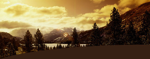
Climate Patterns The territory of the State of Jammu and Kashmir lies between four degrees of latitude from 32.17 to 36.58 North. Within these 640 Kms. there is a sudden rise of altitude from 305 metres to 6910 metres above sea level. The State of Jammu and Kashmir, therefore, lies between the hot plains of the Jammu Province and coldest dry table-land of Ladakh. These territories are, as such, transitional in climate. Weather conditions are different at different places. There are many causes of difference: 1. Relief is the main factor. Lofty mountains like the Pirpanjal, the Zanskar and the Karakoram check winds from blowing in thus moisture is stopped from entering the valleys by the lofly mountains. 2. The Monsoon winds in summer cause rain in the Outer Plains and the Outer Hills. But these winds can cross the Pirpanjal range only when they are very strong. In winter winds from the Mediterranean cause snow and rain in the Valley of Kashmir. Snow falls on the mountains which enclose the valley. 3. Forests influence winds, rainfall and temperature. The moisture laden winds cause rainfall in the forests on the hills making the temperature to fall in summer. Thus the climate of Pahalgam, Gulmarg etc. is comparatively milder than that of Srinagar or Sopore. 4. Altitude is also a factor. So the climate of the valley of Kashmir is comparatively milder than that of the Outer Plain that lie on a very low altitude. The rainfall also varies as the altitude rises. Climate of Kashmir The climate found in the zone of the Middle Mountains and the valleys enclosed is of a particular type. Altitude determines the degree of coolness and elevation the form of precipitation and summer temperature. Winter is cold and of long duration. When the monsoons are strong, rain is caused. In higher mountains round the valley of Kashmir, winter is very cold and there is snow-fall. Summer is very short and milder. The climate in the Valley of Kashmir has its own peculiarities. Winter is very cold. It lasts from November to March. During these months strong winds bring snow and rain from the Mediterranean depressions. These come over from Iran and Afghanistan. Spring begins after 15th of March when rain falls heavily. It causes landslides. But for sowing crops this rain is extremely useful. Rainfall in July and August is as high as 70% and with summer temperature, it causes discomfort. The lakes and waterways make the atmosphere damp and oppressive. The entire valley is covered with a haze that hides the surrounding mountains from view. The seasons are marked with sudden change and the year is divided into six seasons of two months each.
| Spring | March 15 to May 15. |
| Summer | May 15 to July 15. |
| Rainy Season | July 15 to Sept. 15. |
| Autumn | Sept. 15 to Nov. 15. |
| Winter | Nov. 15 to Jan 15. |
| Ice Cold | Jan. 15 to March 15. |
From December 24 to March 8 temperature is often below zero. Strong winds blow from south and southeast. It snows during winter and there are thick black clouds in the sky.
Annual rainfall of the valley recorded is about 75 cms. It rains in July and August and also in March and April . August is the warmest month. Temperature rises to 85 deg. F. January is the coldest month. Temperature falls down to below zero. Longest sunshine hours are in September, October and November.December has 80% humidity which is the highest and May has 71% which is the lowest. In July atmosphere has a pressure of 62.68 cms.
GEOGRAPHY OF JAMMU AND KASHMIR STATE Physical Divisions, Mountains and Passes Kashmir or the Jhelum Valley is situated between the Pir Panjal range and the Zanskar range and has an area of 15220 sq kms. It is bounded on all sides by mountains. The river Jhelum, which flows out from the spring at Verinag in Anantnag district, passes through this Valley at a very slow speed and ultimately flows out through a narrow gorge at Baramulla. Districts of Srinagar, Anantnag, Baramulla, Kupwara and Pulwama lie in this valley. Average height of the valley is 1850 metres above sea level but the surrounding mountains, which are always snow-clad, rise from three to four thousand metres above sea level. The surface of the valley is plain and abounds with springs, lakes and health resorts. Rice is the main crop and fruits like apples, pears, apricots, almonds, walnuts, peaches and cherries grow in abundance. The valley is also rich in forests. Mulberry trees grow in abundance and are the mainstay of silk industry in the Valley. Summer is pleasant but winter is cold and there is snowfall. It rains from the middle of March to the middle of May in the valley with an annual rainfall of about 75 cms. Road transport is common in the valley but the river Jhelum still serves as one of the means of transportation. There is also Air Service from Delhi and Jammu to Srinagar and Ladakh. Kashmir is the home of handicrafts like wood carving, papier-mache, carpet, gabba and shawl making and embroidery on clothes. Natural scenery of the valley attracts thousands of visitors every year from abroad. People generally speak Kashmiri and their common dress is phiran, shalwar and a turban or a Kashmiri cap. There are also some small valleys in this region. On the north of Baramulla is Lolab valley which is 6 Kms long and 4.4 Kms wide. It has many meadows and grovesof walnut trees. Forests are so thick that they hide villages in them. Nullah Sind is the largest tributory of the river Jhelum. The Nullah Sind valley is 100 Kms long upwards and its scenery is diversified. At the head of the valley is the Zojilla pass which leads to Ladakh. Towards Pehlgam lies the Lidar Valley. Its length is 64 Kms. It has small glaciers, grassy meadows, huge rock walls and gorges in its upper mountains. The path to the holy Amarnath cave passethrough this valley. The Kolohai and Sheshnag streams join at Pahalgam to form the Lidar river. Mountains and their Passes Mountains have a special geographical importance to the State of Jammu and Kashmir. Kashmir valley is enclosed by high mountain-chains on all sides except for certain passes and a narrow gorge at Baramulla. There are Siwalik hills towards the south and very lofty mountains in the north, the peaks of which always remain covered with snow. There are volcanic mountains too in the State. They have caused havoc in Kashmir in the past. Some of the famous mountains and their passes are: 1. Karakoram (8615.17 M) and Kyunlun Ranges: 2. Zanskar Range: 3. Nun Kun Range: 4. Nanga Parbat Range: 5. Harmukh Mountain: 6. Burzil Mountain: 7. Amarnath Mountain: 8. Toshmaidan: 9. Afarwat: 10. Pirpanjal Range: 11. Siwalik Range: 12. Volcanic mountains: There is a temple on this peak and many sulphur springs are found at the foot of the hill. These volcanic mountains are the cause of earthquakes in Kashmir. So far twelve devastating earthquakes have occurred in Kashmir. Of these the earthquake of 1885 was the most devastating. Hundreds of houses collapsed, thousands of people died and there were cracks in the earth as a result of this earthquake. Physical Divisions, Mountains and Passes Kashmir or the Jhelum Valley is situated between the Pir Panjal range and the Zanskar range and has an area of 15220 sq kms. It is bounded on all sides by mountains. The river Jhelum, which flows out from the spring at Verinag in Anantnag district, passes through this Valley at a very slow speed and ultimately flows out through a narrow gorge at Baramulla. Districts of Srinagar, Anantnag, Baramulla, Kupwara and Pulwama lie in this valley. Average height of the valley is 1850 metres above sea level but the surrounding mountains, which are always snow-clad, rise from three to four thousand metres above sea level. The surface of the valley is plain and abounds with springs, lakes and health resorts. Rice is the main crop and fruits like apples, pears, apricots, almonds, walnuts, peaches and cherries grow in abundance. The valley is also rich in forests. Mulberry trees grow in abundance and are the mainstay of silk industry in the Valley. Summer is pleasant but winter is cold and there is snowfall. It rains from the middle of March to the middle of May in the valley with an annual rainfall of about 75 cms. Road transport is common in the valley but the river Jhelum still serves as one of the means of transportation. There is also Air Service from Delhi and Jammu to Srinagar and Ladakh. Kashmir is the home of handicrafts like wood carving, papier-mache, carpet, gabba and shawl making and embroidery on clothes. Natural scenery of the valley attracts thousands of visitors every year from abroad. People generally speak Kashmiri and their common dress is phiran, shalwar and a turban or a Kashmiri cap. There are also some small valleys in this region. On the north of Baramulla is Lolab valley which is 6 Kms long and 4.4 Kms wide. It has many meadows and grovesof walnut trees. Forests are so thick that they hide villages in them. Nullah Sind is the largest tributory of the river Jhelum. The Nullah Sind valley is 100 Kms long upwards and its scenery is diversified. At the head of the valley is the Zojilla pass which leads to Ladakh. Towards Pehlgam lies the Lidar Valley. Its length is 64 Kms. It has small glaciers, grassy meadows, huge rock walls and gorges in its upper mountains. The path to the holy Amarnath cave passethrough this valley. The Kolohai and Sheshnag streams join at Pahalgam to form the Lidar river. Mountains and their Passes Mountains have a special geographical importance to the State of Jammu and Kashmir. Kashmir valley is enclosed by high mountain-chains on all sides except for certain passes and a narrow gorge at Baramulla. There are Siwalik hills towards the south and very lofty mountains in the north, the peaks of which always remain covered with snow. There are volcanic mountains too in the State. They have caused havoc in Kashmir in the past. Some of the famous mountains and their passes are: 1. Karakoram (8615.17 M) and Kyunlun Ranges: 2. Zanskar Range: 3. Nun Kun Range: 4. Nanga Parbat Range: 5. Harmukh Mountain: 6. Burzil Mountain: 7. Amarnath Mountain: 8. Toshmaidan: 9. Afarwat: 10. Pirpanjal Range: 11. Siwalik Range: 12. Volcanic mountains: There is a temple on this peak and many sulphur springs are found at the foot of the hill. These volcanic mountains are the cause of earthquakes in Kashmir. So far twelve devastating earthquakes have occurred in Kashmir. Of these the earthquake of 1885 was the most devastating. Hundreds of houses collapsed, thousands of people died and there were cracks in the earth as a result of this earthquake.
Both these mountains lie to the north and north-east of the State and separate it from Russian Turkistan and Tibet. In the north west, Hindukush range continues towards Karakoram range, where K2 peak, the second highest peak of the world, is situated. Two lofty peaks of Gashorbram (8570 metres) and Masharbram (7827 metres) also lie there. People of Ladakh pass through Karakoram pass (5352 metres) and Nubra pass (5800 metres) while going to Chinese Turkistan and Khattan. One can reach Tibet from Ladakh via Kharudangala pass (5557 metres) and Changla pass (5609 metres).
It is about 600 metres above sea level and separates Indus Valley from the valley of Kashmir; it prevents south-west cold winds from reaching Kashmir. Ladakh region terminates at Zojila pass (3529 metres) from where begins the valley of Kashmir. Poat pass (5716 metres) of this range is also a famous pass in this range.
It lies between Ladakh and kashmir border. It is 7055.1 metres above sea level. To its south-east is situated Kulu and to its north-west is situated Kargil tehsil of Ladakh . One has to pass through Bawalocha pass (4891 metres) to reach Leh (Ladakh) from Kulu. In 1947, when Kargil was attacked by Pakistan, Indian forces, arms and ammunition were sent to Ladakh by the Indian Union through this pass.
This range spreads in Gilgit. Its height is 8107.68 metres above sea level and is utterly devoid of vegetation. It was conquered by the Italian mountaineers in 1954. This is now under the unlawful possession of Pakistan.
This is a range of the Himalayas and is situated at a height of 5141.3 metres above sea level towards Bandipore between the rivers Jhelum and Kishan Ganga valley.
It bifurcates Kashmir and Ladakh on which Burzil pass is situated at a height of 3200 metres above sea level.
This is famous for its holy Amarnath Cave, at a height of 5372 metresabove sea level, which thousands of pilgrims visit every year on Rakshabandan. They have to pass Mahagunas pass (1475 metres) on their way to Shri Amarnathji. Gwasharan (5450 metres) is situated in the Lidar valley towards Pahalgam; on it lies the famous glacier Kolahi. Sheeshnag Mountain also spreads in this valley. It is called Sheshnag as its peaks resemble the heads of seven big snakes.
Toshmaindan (4270 metres) and Kajinag (3700 metres) mountains lie in the Inner Himalayas. They remain clad with snow throughout the year, but during summer when the snow melts, the water flows down into the Jhelum river.
This mountain spreads through the Gulmarg valley. The famous spring Alpathar lies on its peak, from which Nullah Nagal comes out and flows down into the Wullar lake.
It separates Kashmir valley from the outer Himalayas and is about 2621 Kms. in length and 50 Kms. in breadth. Famous Banihal pass (2832 metres) lies in the shape of a tunnel on its peak; it remains covered with snow during winter making it impassable. Now at a height of 2200 metres above sea level a new tunnel 'Jawahar Tunnel' has been constructed. The tunnel is 2825 metres long and it was opened for traffic on 22nd Dec. 1956. On the other end of this range lie Baramula pass (1582 metres) and Hajipir pass(2750 metres). Hajipir joins Poonch and Uri. During 1965 Indo-Pak war, the Indian army had occupied this pass. Later on it was handed over to Pakistan.
These hills extend from the north of the outer plains to middle mountains of the State reaching heights varying from 600 metres to 1500 metres above sea level.
One volcanic peak, 'Soyamji' (1860 metres) is situated in North Machhipura (Handwara) and the other 'Kharewa' peak lies in Tehsil Pehalgam, which is dead so far; the former, however, continued eruption of lava for about l3 months during 1934.